All Volunteers must be inducted by a Picton Dawn Chorus staff member before checking our traplines.
Contact us to arrange your induction
Contact us to arrange your induction
Trap lines in Reserves and Parks
We currently have 25 trap lines and over 1014 traps in parks and reserves around Picton which are serviced by our wonderful volunteers.
Below is an overview of the location and names of our trap lines, including a brief description of each line.
Colour coding indicates the ‘degree of difficulty’ from green to red for each line, based on feedback from our volunteers.
Below is an overview of the location and names of our trap lines, including a brief description of each line.
Colour coding indicates the ‘degree of difficulty’ from green to red for each line, based on feedback from our volunteers.
Southern end of the Victoria Domain:

Kaka - Lower Bob's Bay track plus a section up to the ridge.
Kakariki - Upper Bob's Bay track (creates a loop with the Kaka line).
Kiwi - This starts from the Water Tank Reservoir (Harbour View Track) and follows along the Ridge Road of Victoria Domain.
Korimako (Bellbird) - Park at the Sussex Street playground. Head up the Scout track and down the tarmac road back to the playground.
Pipiwharauroa (Shining cuckoo) - Park at the Sussex Street playground. As you look up the tarmac road, there is a track that heads into the bush, uphill from the main Picton-Waikawa walking track. There is a wooden sign hidden in the flax bush. Follow the bike track and head up towards the water tower (but you don’t reach it) and then back to Picton marina.
Ruru (Morepork) - Start at the Leicester Street entrance to the Domain. Head up the hill on the bike track, up to the ridge and back down again to the starting point.
Tara Timms - From Shelley Beach, take the Harbour View Track. The trap line starts after the Harbour View Track splits from Upper Bobs Bay Track and finishes just before you reach the water tank reserve.
Tui - The marina to marina track from Picton to the Pavilion. This starts behind the boat sheds where the rowing club gym is and ends where the track crosses Joseph Sullivan Drive.
Northern end of the Victoria Domain including the Snout:
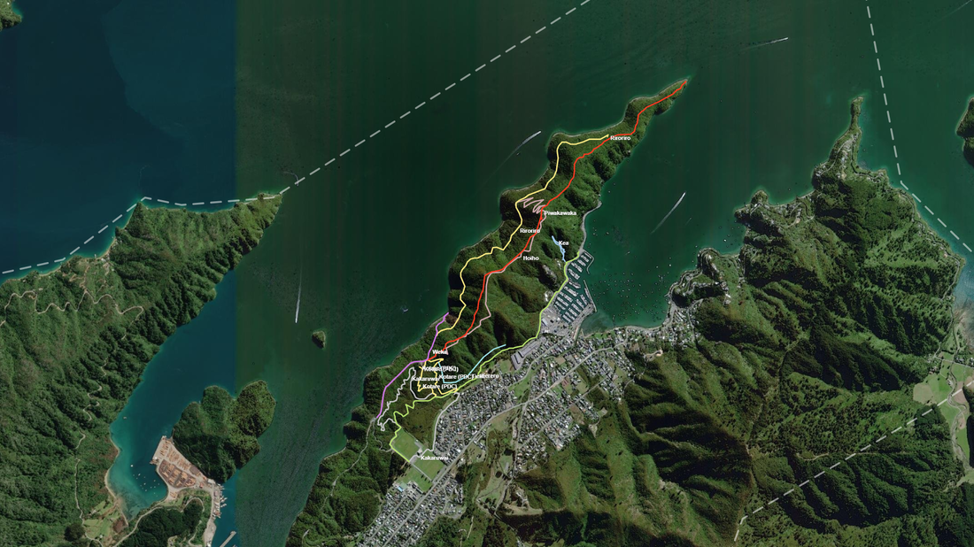
Hoiho (Yellow-eyed penguin) - Follows the Centennial Mountain Bike track, which starts just to the right of the entrance gate to the Snout track. Hoiho track eventually crosses the Snout (Piwakawaka track).
Kakaruwai (South Island robin) - Start and end at Ranui Street. Walking track through Sue's MTB loop track, back onto the Picton Waikawa walking track.
Kea - Bush line starting behind the second ablution block on the west side of Waikawa Marina. Off-track and only for some volunteers.
Kereru - The marina to marina track from the Pavilion to Waikawa Marina. Park at the Pavilion car park. Walk up the side of the sports field parallel to Joseph Sullivan Drive until you meet the Picton-Waikawa walking track. Turn right and head towards Waikawa, finishes at the western side of the marina.
Kotare (Sacred kingfisher) - Park at the end of Ranui Street, head across the creek. Pass the end of the GDS mountain bike track on your right. Take the next gravel track up towards the ridge line and the Kotare traps are on this track going up to the ridge and back down the GDS mountain bike track.
Piwakawaka (Fantail) - The original Snout walking track, starts at the gate to the Snout walking track.
Riroriro (Grey warbler) - The Kanuka Mountain Bike track. This track runs parallel to the Snout walking track on the Western side and then joins up with the Snout track. As you look towards the end of the Snout just before the Snout gate, there is a track to your left that heads downhill towards the “Western MB trail”, and pine beach - this is the Kanuka Mountain Bike track.
Weka - Park at the Snout carpark and then along the ridge walking track towards the Snout. However, before the Snout gate, take a left and head down to Pine Bay and returns to the starting point.
Esson's Valley, Tirohanga Track, Dog Park & Transfer station:
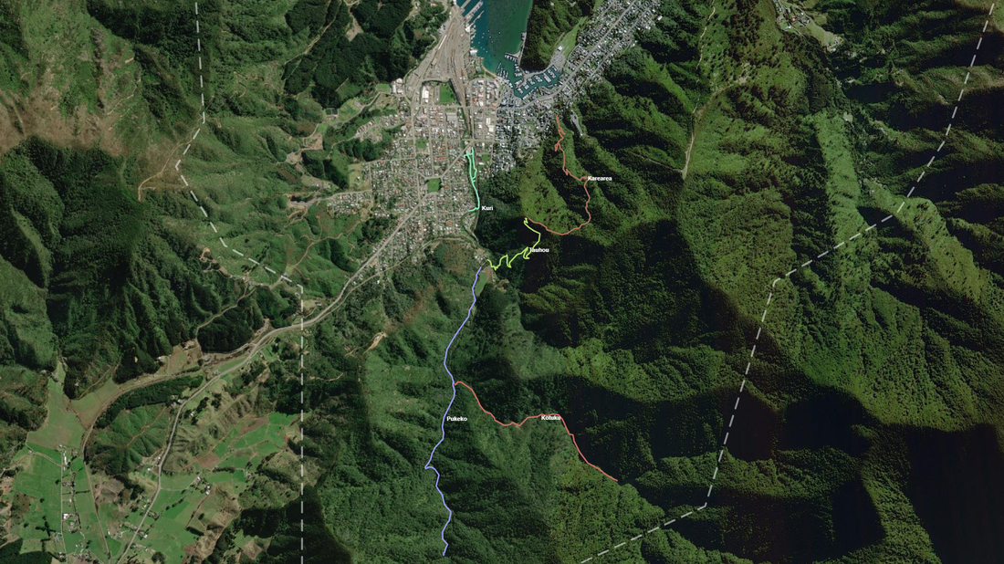
Esson's Valley: (Take a PLB with you on these lines; parts of the tracks have no phone reception)
Kotuku (White Heron) - From the split on the track to the Barnes dam. Park at Esson’s Valley and start walking the track. When you reach the split in the track, take the left fork to Barnes Dam. The traps start here. (Please note: The last third of the track is not to be recommended for people with balance issues, leg joint problems or unsteady footing. Please wear sturdy footwear with good grip, especially on wet days when the track gets slippery.)
Pukeko - Park at the Esson's Valley carpark, walk the track to the Humphries dam. The traps start straight after the gate.
Tirohanga track:
Karearea (New Zealand falcon) - From Newgate street up to the lookout on the Tirohanga track.
Tauhou (Waxeye) - From the Esson's Valley car park up to the Tirohanga track.
The Dog Park:
Kuri (Polynesian dog) - From the Canterbury Street entrance to the dog park heading clockwise to the skate park.
The Wedge:
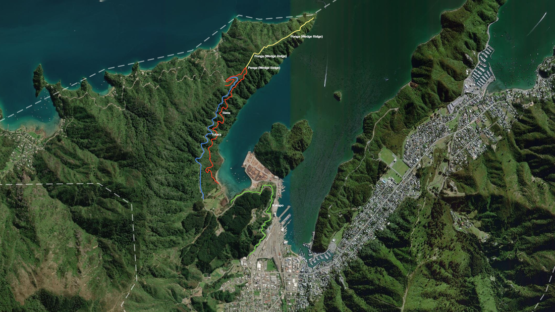
Ponga - From the Link Pathway Lookout heading down the ridge towards Te mimi o kupe. A24s, Flipping Timmy Traps and DOC200. Off-track and only for agile volunteers.
Totara - On the downhill side of the Queen Charlotte Drive between Shakespeare Bay and the Wedge. Must be done by bike.
Rimu - The Link Pathway from the Wedge down to Shakespeare Bay (including to the lookout).
Kakapo - This line starts opposite the blue “Queen Charlotte Drive” sign just after U Lockit Storage Units following the Link Pathway to Shakespeare Bay.
